Level of surfing
Competent
Quality of surf
Good
Call code
692
Net code
mh
Area
181
Coastline
370 km
Climate
Tropical; hot and humid; wet season May to November
Hazards
Very Isolated, Difficult Access
Best Months
November - February
Population
61963
Currency
United states Dollar (USD)
Time Zone
(UTC+12)
Special Requirements
Private Beaches, Special Pass / Permits
introduction
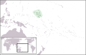
Wrh2: Location map for Marshall Islands, 17 July 2006
The Marshall Islands are a group of atolls and reefs in the Pacific Ocean, about half-way between Hawaii and Australia. There are two island chains of 30 atolls and 1,152 islands of low coral limestone and sand.
The climate in Marshall Islands is usually hot and humid, and wet seasons are from May to November. Most Marshallese speak Marshallese and English. One important word in Marshallese is "yokwe" which is similar to the Hawaiian "aloha" and means "hello", "goodbye" and "love".
surfing
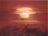
US DoD:Hell in the Pacific - Shot Castle Bravo; 2005
A pitching deck, the creak of well worn timbers, the cracking of sail and canvas...tied to the mast. Things have changed a little I guess from when Jack London and Josef Conrad wrote their haunting Pacific infused epics but it hasnt changed everythwhere. There are corners of this earth where that mythos still holds true, and most of those corners are here in the South Pacific.
The main source of swell here is from the intense lows that circle the earth south of Australia, these lows spin off northwards with blessed regularity, peppering the entire region with generous SE to SW groundswell from March to September. Australia and New Zealand see the bulk of these swells. These countries cast a very tall shadow across the rest of the Pacific and hence many other islands in their wake can suffer from swell difusion. December to February is cyclone season. Unpredictable cells can deliver swell in a 360 radius, lighting up rarely breaking reefs and points facing every conceivable direction.
The South Pacific trade winds are some of the most consistent in the world, generally from the East with slight seasonal variation. This is the largest Ocean on the planet and these winds easily generate regular rideable swell. Onshore conditions can be a problem on east facing coastlines but peeling yourself out for an early surf will usually bring some relief.
In the North Pacific it is the intense lows descending from the Aleutians that deliver NE to NW swells from October to March. Hawaii is ideally placed to make best use of this energy but other coastlines in the region have their own less publicised and far less crowded gems.
Jun to October also sees rarer hurricane swell radiate out from southern Mexico. This energy is often felt right throughout Polynesia. With so many energy vectors at work it is very hard not to find a wave.
Places such as the Marshall Islands that offer rideable options on every coast will ensure that regadlesss of the conditions, somewhere there will be a wave. In fact quite often there will be a very good one.
travel
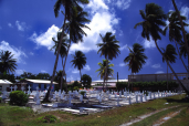
Stefan Lins: The Marshall Islands - Majuro - Burial grounds, 1 March 2000
Getting to Marshall Islands requires a flight to the Marshall Islands International Airport in Majuro, the Bucholz Army Airfield in Kwajalein, and other small airports.
Air Marshall Islands provides regular scheduled internal flights to 10 of the atolls in the Marshall Islands and has planes available for charter. Flights are available between Honolulu and the Marshall Islands and to Fiji via Kiribati and Tuvalu. From New York to Majuro it takes approximately 14 hours; from Tokyo 1 and from Guam 8.
weather
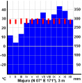
Miaow Miaow: Climate diagram of Majuro, Marshall Islands, April 2005
The climate is hot and humid, with a wet season from May to November.
As the islands border the typhoon belt, it occasionally suffers from typhoons. Many Pacific typhoons start in the Marshall Islands region but grow stronger as they move west toward the Mariana Islands and the Philippines.
what to pack
Rich Niewiroski Jr.: 62 mm ultra-violet, fluorescent, and polarizing lens filters. Camera used was a Canon 400D; April 9, 2007
Pack light, there's no need to bring your expensive belongings. Going to a sunny country, which is near Ecvator, make sure you take a good sunscreen (SPF 30+), sunglasses; a good insect repellent is a must. Comfortable walking shoes, sandals, hat and natural fabrics (such as cotton or linen) clothes will be useful as well.
Take your camera and all the equipment for it with the protection from the sand. Don't forget a backpack and rehydration sachets, that might be usefull if your planning to travel around or sail. And you won't regret swimming and snorkelling gear!
top rated spots
surfing divisions
Partners