United States Pacific Island Wildlife Refuges
North Pacific OceanLevel of surfing
Advanced
Quality of surf
Good
Area
6959
Coastline
91 km
Climate
Tropical Maritime
Hazards
Very Isolated, Cyclones, Severe Storms, Difficult Access
Best Months
May - September
Time Zone
Hawaiian Standard time HST (HST) WHISKY (UTC-10)
Special Requirements
Private Beaches, Special Pass / Permits, Lengthy VISA Process, Non tourist Friendly
intro

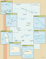
Hoshie: United States Pacific Island Wildlife Refuges-CIA WFB Map; 25 August 2007
Pacific Remote Islands National Wildlife Refuge Complex is a group of unorganized, unincorporated (or in the case of Palmyra Atoll, incorporated) US Pacific island territories, managed by the Fish and Wildlife Service of the US Department of Interior. These remote refuges are the most widespread collection of marine- and terrestrial-life protected areas on the planet under a single country's jurisdiction. They protect many endemic species including corals, fish, shellfish, marine mammals, seabirds, water birds, land birds, insects, and vegetation not found elsewhere.
history

The islands have no indigenous inhabitants. Almost all of the seven islands (Baker Island, Howland Island, Jarvis Island, Johnston Atoll, Kingman Reef, Midway Islands, Palmyra Atoll) were discovered and possessed by Unites States.
Baker Island: It was possessed by US in 1857 and in 1935 there was an attempt to colonize the island, wich was disrupted by World War II and thereafter abandoned. The island was established as a National Wildlife Refuge in 1974.
Howland Island: The island was officially claimed by the US in 1857 and again there was an attempt to colonize the island in 1935 (similar to Baker Island), disrupted by World War II and thereafter abandoned. There is a day beacon near the middle of the west coast, called Earhart Light, named in the memory of the American aviatrix Amelia Earhart who disappeared while seeking out Howland Island as a refueling stop during her 1937 round-the-world flight. The island was established as a National Wildlife Refuge in 1974.
Jarvis Island: The island was uninhabited as well and first discovered by the British in 1821,
then annexed by the US in 1858, but abandoned in
1879 after tons of guano had been removed. Jarvis Island was annexed by UK in
1889 with no plans for further exploitation. After that it was occupied and reclaimed by US and then abandoned in
1942 during World War II. The island was established as a National
Wildlife Refuge in 1974.
Johnston Atoll: Annexed by the US and the Kingdom of Hawaii in 1858 (with US mining the guano
deposits until the late 1880s). In 1926 Johnston and Sand Islands were
designated wildlife refuges. The US Navy took over the atoll in
1934, and the US Air Force assumed control in 1948. The
site was used for high-altitude nuclear tests in the 1950s and 1960s,
and until late in 2000 the atoll was maintained as a storage and
disposal site for chemical weapons. Munitions destruction is now
complete with the cleanup and closure of the facility completed by May
2005. The Fish and Wildlife Service and the US Air Force are currently
discussing future management options; in the interim, Johnston Atoll
and the three-mile Naval Defensive Sea around it remain under the
jurisdiction and administrative control of the US Air Force.
Kingman Reef: Annexed by the US in 1922. Its
sheltered lagoon served as a way station for flying boats on
Hawaii-to-American Samoa flights during the late 1930s. Though there are no
terrestrial plants on the reef, which is frequently awash, it does
support abundant and diverse marine fauna and flora. In 2001, the
waters surrounding the reef out to 12 nm were designated a US National
Wildlife Refuge.
Midway Islands: The US took formal possession of the
islands in 1867. The laying of the trans-Pacific cable, which passed
through the islands, brought the first residents in 1903. Between 1935
and 1947, Midway was used as a refueling stop for trans-Pacific
flights. The US naval victory over a Japanese fleet off Midway in 1942
was one of the turning points of World War II. The islands continued to
serve as a naval station until closed in 1993. Today the islands are a
National Wildlife Refuge and are the site of the world's largest Laysan
albatross colony.
Palmyra Atoll: Was claimed by the Kingdom of Hawaii in 1862, and the US included it among the Hawaiian Islands when it
annexed the archipelago in 1898. The Hawaii Statehood Act of 1959 did
not include Palmyra Atoll, which is now partly privately owned by the
Nature Conservancy with the rest owned by the Federal government and
managed by the US Fish and Wildlife Service. These organizations are
managing the atoll as a wildlife refuge. The lagoons and surrounding
waters within the 12 nm US territorial seas were transferred to the US
Fish and Wildlife Service and designated as a National Wildlife Refuge
in January 2001.
surfing
CIA WFB: United States Pacific Island Wildlife Refuges; 2007
The seven remote island that comprise the US Pacific Islands Wildlife Refuges group are spread over several thousands of miles of the north and south pacific. Each one of these islands is a mere speck of land surrounded by the vastness that is the Pacific Ocean. Each of these islands are exposed to either the North Pacific swell systems that power Hawaii or the attenuated pulses of SW swell that filter through Polynesia to the south - either way they all have surf, the real challenge here however is not only getting to these uninhabited islands but receiving permission to surf them.
You will need an ocean going vessel and permission from the US fisheries and Wildlife Service to set foot on these islands and typically this is only granted to scientists and researchers that study the rare endemic wildlife that live here. Johnston Atoll with only 2.6 square kilometres of land was host to around 1100 US scientific personnel around 2005 and many of them had boards. Legendary stories exist of some of the sessions these surfers enjoyed in the middle of the ocean around this atoll, the most notable being Epsilon 4, who else but a scientist would name a surf break Epsilon 4.
Baker island at 129 square kilometres is the largest and offers far more variety. some of the islands are barely above the high water chart datum level, all excellent reef breaks but very sensitive to swell direction. If you ever do find yourself in the vicinity of these islands, avoiding setting foot on land if possible and be very careful not to cause any damage to the sensitive pristine reef systems. Many of these have as yet been unspoilt from human intervention and may hold the key as to how we can heal the remainder of our planets endangered reefs.
what to pack

Rich Niewiroski Jr.: 62 mm ultra-violet, fluorescent, and polarizing lens filters. Camera used was a Canon 400D; April 9, 2007
A small backpack makes a good carryon bag and will be useful in daily life. A pair of comfortable walking shoes will be great for walking. Beach clothing & sandals will be useful if you are going in the warm season. Cotton is the best.
Definitely take along some bug repellent spray, good sunscreen and sunglasses! Better take your medicines with you and a good protection for your camera from the sand.
You may also need a pair of waterproof boots and a good backpack if you plan to explore the islands. Depending on the season tropical rains can be quite often, so it’s a good idea to take something waterproof if you plan to go outside. Another option would be just to stay at you place and have a nap – the whole atmosphere is very laidback.
top rated spots
surfing divisions
Partners